Image

Dr Alexis Litvine
Senior Researcher, The Cambridge Group for the History of Population and Social Structure (CAMPOP)
Aviva’s archive contains more than 325 years of insurance history. After more than two years of digitisation – covering around 550,000 policy entries – this vast resource is now helping to build a clearer picture of how London looked hundreds of years ago.
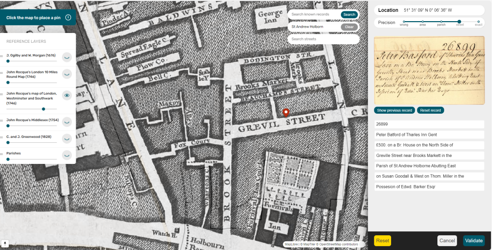
The Amicable Contributors digital tool is a new crowdsourcing project and website developed by researchers at the University of Cambridge in partnership with Aviva. It invites people to plot a digital map of properties insured in London from the 1690s to the 1860s: from mansions and hospitals to workshops and poorhouses. Users can easily search extracts of the digitised policies - transcribed by an automated handwriting recognition tool - for references to the parish, road name or other geographical markers (‘west of the Tower’) in order to locate buildings.
This project was made possible through the University’s partnership with Aviva, working closely with the company’s archivists. It is powered by a new technology developed by the Cambridge Group for the History of Population and Social Structure (CAMPOP) – hosted within the University's Faculty of History – and a new spin-out company, led by CAMPOP Senior Researcher Dr Alexis Litvine and supported by Cambridge Enterprise. This Osiris-AI tool captures the data and transcribes it automatically.
The Amicable Contributors site combines the cutting-edge AI techniques with crowdsourcing for historical data acquisition and consultation in innovative ways. More than that, as Litvine continues: “the resulting dataset will provide an unprecedented view of London’s property market from the 1690s to the mid-19th century”.
Crowdsourcing is a deliberate choice. Geotagging a location within an urban area is not very precise and historic gazetteers are not always sufficient wayfinders. With over half a million policies to geolocate, crowdsourcing can improve accuracy. But this is also fun detective work. Locating these buildings across London using beautiful historical maps is an engaging way to discover these archives. Aviva hopes to make the completed maps publicly available in the future.